Cartographic Counter-Statecraft: India’s Arunachal Pradesh Mapping and China
Introduction
Maps are not merely geographical representations; in contested territories, they can become instruments of sovereignty, state authority and geopolitical communication. By formally identifying 27 locations and geographical features within Arunachal Pradesh, New Delhi is reinforcing the administrative and territorial narrative that these areas form an established part of India. Although changing a name does not alter sovereignty under international law, repeated official usage can contribute to a state’s attempt to normalise its territorial narrative. India’s recent updating of the official map of Arunachal Pradesh has a great importance amid its 2026 BRICS presidency. The move comes at a particularly sensitive stage in India-China relations. Because at this stage, both countries are making efforts to stabilise bilateral ties while continuing to disagree fundamentally over the boundary question.
The Cartographic Context
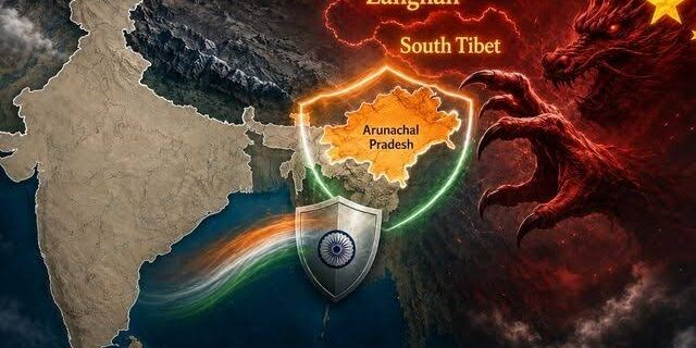
The Arunachal Pradesh issue is part of a longstanding territorial dispute between India and China. Beijing refers to Arunachal Pradesh as “Zangnan” or “South Tibet” and has repeatedly attempted to reinforce its territorial claim through the renaming of geographical features. In 2017, in China’s first list announced names for six locations, in 2021, the second list, 15 locations, and in April 2023, third list, for another 11 locations and in 2024, approximately 30 locations of Arunachal Pradesh. Though, India rejected the exercise and repeated that Arunachal Pradesh is an integral and inalienable part of India. The Survey of India already maintains an official Arunachal Pradesh state map, with its current state-map listing showing a 3rd/2025 edition. So, the latest Indian initiative can be understood as a response within an emerging “cartographic contest” between the two countries. Consequently, the map update should be interpreted alongside India’s broader effort to improve infrastructure and administrative presence in border areas.
These locations are strategically important for India’s border strategy against China and these locations includes border locations like Long Ju and Thag La. In 1962, the war between India and China started from these locations. It includes strategic passes like Bisa, Dzo La, Riza La, and Thag La. Jairampur is another location included in these 27 locations, is an important logistics hub in Changlang district and also significant for movement towards eastern Arunachal Pradesh and the Myanmar border. Few cultural and historical sites are also included in these locations like Jaswant Garh (commemorating Jaswant Singh Rawat), Sher-e-Thapa Memorial (honouring 1962 war hero Trilok Singh Thapa). It also includes Sambho Sarovar which is a high-altitude lake. In this background, the Arunachal Pradesh map update proves that India’s pro-active diplomacy for safeguarding national interest and sovereignty. It also shows the “Nation First” policy of the Indian government.
Strategic Significance of Arunachal Pradesh
Arunachal Pradesh occupies an exceptionally important position in India’s Himalayan security architecture. It shares a long and sensitive frontier with China and provides India with strategic depth in the eastern sector. The region surrounding Tawang is particularly important. Tawang has military, geographical, cultural and historical significance and lies close to the India-China boundary. The updated mapping of strategically significant locations therefore contributes to greater visibility of areas that have historically been associated with border tensions and military confrontation.
From Cartographic Assertion to Physical Presence
The significance of the map becomes greater when considered together with India’s border-development policies. Under the Vibrant Villages Programme, the Government has identified hundreds of villages in Arunachal Pradesh for comprehensive development. As of July 2026, 455 of the 662 priority villages under the programme were located in Arunachal Pradesh. India is increasingly combining cartographic sovereignty with infrastructural sovereignty. In other words, New Delhi’s approach is no longer restricted to asserting territorial claims diplomatically. It is simultaneously: mapping strategically important territory, improving road and bridge connectivity, strengthening border villages, enhancing administrative presence, improving communications and essential services; and, increasing the capacity for rapid movement of security forces. Such measures strengthen India’s ability to sustain its territorial position in the eastern Himalayas.
Diplomatic Signal to China
The updated map can be interpreted as a calibrated diplomatic signal to Beijing. Rather than constituting an immediate military escalation, cartographic standardisation represents a relatively low-cost but highly visible instrument of strategic signalling. It tells China that India’s position on Arunachal Pradesh is institutionalised across its administrative and cartographic apparatus. This becomes particularly relevant because India and China have continued mechanisms for managing the boundary dispute. The 35th meeting of the Working Mechanism for Consultation and Coordination on India-China Border Affairs was held in Beijing on 27 May 2026, demonstrating that diplomatic and institutional channels remain active. The map update therefore reflects a dual-track policy: dialogue with China on the one hand and firm territorial assertion on the other.
Implications for India-China Relations
The immediate consequence is likely to be another episode of diplomatic friction. China has already objected to India’s identification of the locations, while India’s Ministry of External Affairs has reiterated that Arunachal Pradesh is an “inalienable and integral” part of India.
The broader implication is more important. The boundary question increasingly affects the entire architecture of India-China relations. India’s latest position indicates that the state of the border is directly connected with the overall trajectory of bilateral ties. Thus, the relationship is likely to remain characterised by competitive coexistence: economic and multilateral engagement may continue, but strategic trust will remain constrained by the unresolved boundary dispute.
Implications for the 2026 BRICS Summit
The development also creates an interesting diplomatic environment for the forthcoming BRICS Summit in India. Since China is a core BRICS member, the Arunachal issue could potentially cast a bilateral shadow over a summit that India would prefer to use for demonstrating its leadership of the Global South. However, this need not necessarily undermine India’s BRICS presidency. Rather, it may reinforce India’s preferred model of strategic autonomy. India can simultaneously cooperate with China on global economic and developmental issues while maintaining a firm position on territorial sovereignty.
Strategic Consequences for India
The map update has several long-term strategic consequences. First, it strengthens India’s territorial narrative. Second, it complements border infrastructure development. Mapping strategically significant locations creates greater coherence between territorial assertion and physical state capacity. Third, it strengthens deterrence. Although a map itself has no direct military capability, it forms part of a broader signalling strategy demonstrating political resolve and administrative control. Fourth, it counters China’s “renaming strategy”. India’s action establishes an institutional counter-narrative to China. Fifth, it enhances India’s strategic autonomy.
Conclusion
India’s updated Arunachal Pradesh map during its 2026 BRICS presidency should therefore not be dismissed as a routine cartographic exercise. It represents an important component of India’s broader territorial, diplomatic and strategic signalling toward China. The significance lies particularly in the combination of three developments: cartographic assertion, border infrastructure and diplomatic engagement. India is simultaneously strengthening its physical presence along the frontier, institutionalising its territorial narrative and maintaining dialogue with China. The timing during the BRICS presidency is especially noteworthy. It demonstrates that India’s engagement with China is becoming increasingly compartmentalised and interest-driven.
References
Government of India, Ministry of Home Affairs (2026), Government of India in consultation with Government of Arunachal Pradesh identified 27 places/features located in Arunachal Pradesh by standard place and feature names on the official maps of Survey of India. Press Information Bureau, 7 August 2026.
Survey of India (2026), State Maps: Arunachal Pradesh. Government of India, Department of Science & Technology.
Survey of India (2026), Political Map of India. Government of India, Department of Science & Technology.
Ministry of External Affairs, Government of India (2023), Official Spokesperson’s response to media queries regarding the renaming of places in Arunachal Pradesh by China, 4 April 2023.
Ministry of External Affairs, Government of India (2021), Official Spokesperson’s response to a media query on reports that China has renamed some places in Arunachal Pradesh in its own language. 30 December 2021.
People’s Republic of China, Ministry of Civil Affairs (2024), Fourth batch of standardized geographical names in Zangnan.
Global Times (2024), Reports concerning China’s fourth list of standardized geographical names in “Zangnan”.
Defence Research and Development Organisation (DRDO) (2024), News Digest, 10 April 2024.
Mohan, C. Raja (2012), “Samudra Manthan: Sino-Indian Rivalry in the Indo-Pacific’, Oxford University Press.